higher ground

This black rat snake, likely chased from the den during our recent floods, has discovered a better vantage point for surveying onlookers. I've seen a lot of confused animals over the last couple of weeks, turkeys walking in circles, fawns looking unsure of their next steps, and snapping turtles dragging themselves through high ground.
levee failure

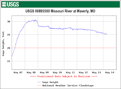
Here's how a levee failure is expressed in terms river stage. The first levee fails just before midnight on the 8th and the river stage drops approximately 2 feet over the next several hours as the flood waters go out onto the floodplain where they are ''stored'' to be released slowly into the underlying aquifer and eventually back into the river. This storage can be a significant amount of water. There is a second, smaller failure about 1800 hours on the 9th. What appears to be failures on the 11th and 13th have not been confirmed from ground observations, there may be other explanations for the declines, it's a little hard to say just from the graph. The net effect of these failures are lower downstream river levels, i.e. at Jefferson City and St. Louis, which is one reason why the flood crest is going to be less than originally predicted and why this flood isn't going to be as bad as feared.
The orginal predictions posted by the National Weather Service did not account for levee failures and rapidly changing conditions (more rain, levee breaks) indicates the need to be continously monitoring river levels during extreme events. You wouldn't really want to have to evacuate a large metropolitan area unless completely necessary, and if you're a Republican, then you might never see the need. I think the Republican motto is don't send in the National Guard until you see the white shirts on the rooftops.
suck on a willow root
The beavers were out today, looking for freshly flood scoured succulent black willow roots on which to snack. Water levels on the Kaw (Kansas) River have dropped precipitously although they are just now peaking on the lower Missouri River below Booneville. The Mo River will remain above flood stage for at least a week to ten days barring no more rain. More precipitation, especially anything nearing a repeat of the rains from last weekend would spell major disaster from Kansas City to St. Louis.
Here's a high water mark in a tree upstream approximately 2 miles from Eudora Kansas. That's a 230 cm paddle for scale and it's resting approximately 75 cm off the ground. Although difficult to see, debris was lodged approximately another blade length (~75 cm) higher in the tree. However, given the size of this tree it was likely bent over some during the flood so the actual flood elevation was likely about the end of the paddle or about 400 cm above the current water surface. 400 cm = 13.1 ft for les Americains. Access to the Kaw River at Eudora is via a 1 mile stretch of the Wakarusa River. If all streams had a riparian corridor that looks like the lower Wakarusa River the world would be a very different and better place. Fifty to 70 percent tree canopy along there. Very nice.
wall to wall


Here are some great false color satellite images of the confluence of the Grand River and the Missouri Rivers. These photos were taken in 1992 (lower image) and then during the historic 1993 flood (upper image). The Grand River is coming in from the northwest (upper right) on these images and then flood waters are filling the entire valley - valley wall to valley wall. The curent flood levels on the Grand and Missouri Rivers at this location are less than in 1993, but appear to be within the top 10 percent of floods since 1900 at this location.
River Refuge @ Alligator Cove (see previous post) is approximately 90 river miles upstream of this location.
Landsat Thematic image. Bands 5, 4, and 2 mapped to red, green, and blue respectively. Images from Goddard Space Flight Center.
refuge


This is Capt. Breyfogle's place, http://www.riverrefuge.com/, about 25 miles east of Kansas City, just east of a little town called Missouri City. I've never understood the Alligator Cove name, but suspect there's a tall tale involved. The small building is a cabin that was elevated on blocks before being floated over on it's side.
Photos. Vicki Richmond. Missouri River Relief.

